News Items > Waymaker Recreation Ground Handcross
Waymaker Recreation Ground Handcross
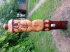
The Waymaker, Recreation Ground, Handcross
A
"waymaker" typically refers to a sign, marker, or monument that helps
guide or direct people along a path, trail, or route. It can serve as a point
of reference, indicating directions, distances, or points of interest. In a
broader sense, it can also symbolize a landmark or feature that signifies a
particular location or destination.
The installation of the
new waymaker was completed on the 19th May, positioned to the left of the
entrance to the Sports Ground.
It is 155cm high x 35cm x 20cm. It will be made up of oak carving with stains. The carvings will have, stage coach wheel, Nymans bird motif, High Beeches gentians, Japanese lantern top, flames Zoar Baptist chapel, which was built around 1782 because of established local need from ‘woodmen and labourers.
The village developed further because it was a stage coach stop on the London to Brighton route. It still tends to be a through route but has very significant gardens close by to spend time in. One is Nymans which was developed by the Messel family and the other High Beeches which was established by a branch of the Loder family, (the family that also established Wakehurst and Leonards Lee). Gentian asclepiadia is a special species that has naturalised at High Beeches and is depicted here with its very sculptural trumpet shaped flowers and spear shaped leaves.
The bird motif used is from the pot in the sunken garden at Nymans and is familiar from many visits over the years. The lantern top is a reference to the fashion for all things Japanese that swept through garden design after the 1903 London exhibition. This top is a composite of the stone lanterns on display at both of these local gardens.
Each Waymarker has a wyvern/dragon symbol to represent the circular routes and options to continue in either direction. Each mythical beast points towards the natural things you may find, but also represents nature regenerating itself alongside development and industry through the ages in each place.
This area of the weald was once covered in forest. The St Leonards Forest came up to Handcross and is known to have a dragon. Sussex has a number of legendary dragons, wyverns and knuckers (water dragons that dwell round springs) they undoubtedly would have inhabited these areas of fire which result from furnaces and charcoal burning.
These are common to the forest areas around the villages and towns of Mid Sussex. The iron industry is a key to the wealth and development of each of the sites, but mythology and wildlife have been able to persist.
This was a partner project with other local parish and town councils through the About the Place, the new Mid Sussex Walking Trail routes. There are seven circular walks and a 40 mile trail, in seven sections, which goes through Ansty, Handcross, Balcombe, Worth, East Grinstead, West Hoathly and Lindfield, all are signposted by a series of eight hand carved oak waymarkers, produced by local artist Janine Creaye.
Slaugham Parish Council 